


Google’s latest Crisis Response Map has been issued for the East Coast of the United States as Hurricane Sandy, a powerful storm that formed in the Caribbean, heads toward New Jersey, New York, Pennsylvania and beyond this weekend, packing heavy rains and winds that could be as strong as 80 mph or greater.
“Just launched: A new crisis map with several Hurricane Sandy-related layers, including current and forecasted locations, courtesy of NOAA-National Hurricane Center; cloud and wind information; and public alerts featuring emergency information like evacuation routes,” according to an Oct. 25 post on the Google Maps Google+ page. “As the team identifies additional information, they’ll be updating the map.”
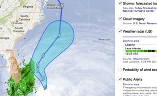
The map shows a wide range of information layers that detail many aspects of the approaching storm, including its current location, forecasted location, weather radar, wind speed probabilities, public alerts, emergency alerts and hurricane evacuation routes, according to the map. Also available are information layers for traffic conditions, active emergency shelters, disaster recovery centers, storm surge zones and catalogs of YouTube videos that have been shot and uploaded to show the effects of the storm.
The layers can be added or removed by map visitors to customize the information they can receive about the progress of the storm, which is expected to dump plenty of rain—and even possibly some snow—across the eastern U.S. Utility companies are preparing for lots of downed power lines, service outages and large cleanup bills, according to reports.
So far, Hurricane Sandy has left 29 people dead as it walloped the Caribbean, while reducing its intensity to a Category 1 hurricane. Earlier it had been a Category 2 hurricane, according to a story from Weather.com.
“Early Friday, the hurricane’s center was about 15 miles east of Great Abaco Island in the Bahamas and 485 miles south-southeast of Charleston, S.C.,” the story reported. “Sandy was moving northeast at 10 mph with maximum sustained winds near 80 mph.”
The hurricane could mix with an approaching winter storm that potentially could create a massive pre-Halloween “Frankenstorm” by early next week, with effects that could be felt from Florida to Maine and inland to Ohio, according to Weather.com.
Google’s Crisis Maps come from the company’s philanthropic division, which last January began a Public Alerts Website to offer important emergency information on storms, hurricanes, earthquakes and other natural disasters and crises. The alerts will tell users what’s happening and when, the severity of the disaster and where to go for help.
Google’s Crisis Response team has been providing such information for the last few years, albeit on a more reactive, rather than proactive, basis.
In August, Google published a Crisis Response map for Tropical Storm Isaac as it approached the U.S. Gulf Coast, and another for massive flooding that occurred in the Philippines following a monsoon. Google also created such maps after earthquakes in Haiti and Chile in 2010, after the tsunami and earthquake in Japan in 2011, and after the BP oil spill in the Gulf in 2010 and the effects of Hurricane Irene in the U.S. in 2011.
Google also recently updated its public alerts to also include tsunami data for the U.S. and Canada. Additional areas will be rolled out in the future, according to the company.