


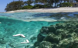

For the first time, Google Maps is adding underwater panoramic images of spectacular reefs around the world to the extensive and growing library of images in its Street View collection.
The new images, of underwater reefs in Australia, Hawaii and the Philippines, come to the Street View collection from the Caitlin Seaview Survey, which is conducting scientific expeditions to explore and map the world’s coral reefs, according to Google.
“Today we’re adding the very first underwater panoramic images to Google Maps, the next step in our quest to provide people with the most comprehensive, accurate and usable map of the world,” wrote Brian McClendon, vice president of Google Maps and Google Earth, in a Sept. 25 post on the Google Lat Long Blog. “With these vibrant and stunning photos you don’t have to be a scuba diver—or even know how to swim—to explore and experience six of the ocean’s most incredible living coral reefs. Now, anyone can become the next virtual Jacques Cousteau and dive with sea turtles, fish and manta rays in Australia, the Philippines and Hawaii.”
The new images will allow online visitors to use Google Maps to see a sea turtle swimming among a school of fish, to follow a manta ray and to experience The Great Barrier Reef at sunset, wrote McClendon. “You can also find out much more about this reef via the World Wonders Project, a website that brings modern and ancient world heritage sites online. At Apo Island, a volcanic island and marine reserve in the Philippines, you can see an ancient boulder coral, which may be several hundred years old. And in the middle of the Pacific, in Hawaii, you can join snorkelers in Oahu’s Hanauma Bay and drift over the vast coral reef at Maui’s Molokini crater.”
The colorful, detailed images were taken using a special tablet-operated underwater camera, the SVll, by the crew members of The Catlin Seaview Survey, wrote McClendon. “Whether you’re a marine biologist, an avid scuba diver or a landlocked landlubber, we encourage you to dive in and explore the ocean with Google Maps.”
The SVll camera is being used to take tens of thousands of images in a continuous high-resolution, 360-degree panoramic project, then the images are stitched together so they appear as one, according to the organizers.
The new Street View image collection will allow millions of people around the globe to see the Great Barrier Reef and other underwater locations for the first time up close, from wherever they live, as part of the Caitlin group’s first oceanic scientific expedition, according to the Queensland, Australia-based group.
“It’s incredibly rewarding and exciting to be leading a talented team of scientists as the first
Catlin Seaview Survey expedition begins,” the project’s chief scientist, Professor Ove Hoegh-Guldberg of the Global Change Institute at The University of Queensland, said in a statement. “The possibilities of what we will discover about coral reefs are almost endless. And right now, information on how these endangered ecosystems are responding to climate change is incredibly important, given that almost 25 percent of marine species live in and around coral reefs.”
All of the scientific data gathered during the expedition will later be made public in a
Global Reef Record database, said Ove Hoegh-Guldberg. “The Global Reef Record is a game-changing scientific tool that scientists around the world will have at their fingertips. They will be able to monitor change in marine environments now and in the future. Marine scientists researching any aspect of the reef will be able to study these environments from any of the surveys we conduct – shallow reef or deep reef.”
The first Catlin Seaview Survey expedition on the Great Barrier Reef began Sept. 16 and runs until the end of December, visiting 20 separate coral reefs along the 1,429-mile-long reef, according to the Caitlin expedition. It will then continue to selected locations in Hawaii, the Philippines and Bermuda in 2013.
The underwater Google Maps images are the latest in the company’s ever-expanding Street View Gallery. In August, Google Maps added its first true “out of this world” images with the addition of detailed 360 degree images taken of retired spacecraft, launching facilities and other notable scenes at NASA’s Kennedy Space Center (KSC) on the Florida coast.